The Advertiser Monday 10 May 1909
DEVELOPING EYRE'S PENINSULA.
FINDING LAND FOR SETTLEMENT.
ROYAL COMMISSION ON TOUR.
(By One of the Party.)
Time and again during the past few weeks the Commissioner of Crown Lands, referring to the Eyre Peninsula Railway Royal Commission, has declared- "This is the most important Commission that has been appointed in South Australia". The remark has been received generally with a look of incredulity by the great majority of the people, and many legislators are in entire ignorance of the possibilities of the vast area of country that stretches for 207 miles between Franklin Harbor and Streaky Bay, and runs northwards from Port Lincoln to Weedina for a distance of about 130 miles The great bulk of the country is good arable land, giving indications of a rainfall sufficient for wheat-growing.
The Commission, which completed its big exploring tour on Sunday, was deputed to enquire into the best means of opening up the peninsula by means of railway communication, and on that matter and the question of rival routes I cannot speak until the report of the Commission has been presented to his Excellency the Governor, but it is advisable to point out at once to the farmers of South Australia that their sons may yet find homes within the State, far removed though it may, be from the farms on which they were reared, and with many pioneering difficulties and hardships to face, but with prospects just as good as those which encouraged their fathers to turn the scrub lands east of Spencer's Gulf into prosperous farms and establish happy homes.
Object of the Commission
The Commission was really appointed to enquire into and report upon the country about Darkie's (sic) Peak and Weedina, and the best means of opening up the land for settlement by means of railway communication. The best information to be had of this country was contained in a report dated August 16, 1886, by Mr E B Jones, a reliable Government officer, who is probably more familiar with Eyre's Peninsula than anyone in the State. In his report Mr Jones states:-
"The area of unleased Crown lands in counties Jervois and Musgrave, and not included within hundreds (with exception of the hundred of McLachlan), is approximately 1,461,760 acres. This area comprises approximately 45,000 acres of good red and chocolate-coloured sandy loam over clay subsoil and rubble, and covered for the most part with dense high mallee and various bushes; 99,000 acres, of fair, and 175,000 acres of fair to medium arable land, the latter area consisting of red loamy and clayey flats, varying in width from 10 to 60 chains, between low sandy ridges, trending generally E.S.E., and covered with mallee, broom and bushes. The remainder may be classed as inferior, and comprises low sandy and stony ridges, covered with low scrub and spinifex. Owing to the absence of any rainfall records pertaining to this locality it is difficult to form a correct opinion as to the suitability of the land for production of cereals, but, as far as I can judge, and from information received, I consider it may be set down at an average of from 14 to 15 ínches. Without facilities being provided to convey produce to shipping ports it would, I consider, be inadvisable to extend the present surveys, the distance to be carted and the sandy nature of the country to be passed over rendering successful occupation prohibitive as far at least, as agricultural pursuits are concerned. A continuation of the present Port Lincoln railway northerly would serve at least 136,600 acres of land suitable for agricultural purposes, but would be of no avail to that situated easterly, to meet the requirements of which a line from Arno Bay would be necessary, and would serve at least 183,000 acres of fair to good arable land, together with a large extent of that already under occupation in hundreds of Mann, Yadnarie, Mangalo, and Campoona. I also, as instructed, inspected the country north of county Musgrave and in the vicinity of Kappakoola and Wudinna, and estimate that an area of at least 200,000 acres of fair to good arable land is available, apart from which there is about 100,000 acres occurring in patches and on flats between sandy ridges which would I consider be brought under successful occupation, providing, however, that facilities are given for conveyance of produce to the seaboard. The rainfall over this area would not, I think, be much less than that for the portions of counties Musgrave and Jervois previously referred to. To summarise the whole of the foregoing:- About 356,000 acres of land suitable for agricultural purposes (subject of course, to rainfall) would be served by an extension, of the present Port Lincoln railway for, say, 90 miles beyond its present proposed terminus; and an additional 183 000 acres by a line from Arno Bay north-westerly for about 30 miles."
Since his latest inspection of the country, Mr. Jones has decided to increase the area of first and second class land to an extent which has not yet been ascertained, but in the eyes of competent judges, and in view of what has been done on the sandy scrub lands of Pinnaroo and elsewhere, there are quite one and a half million acres of land in the northern part of Eyre Peninsula yet to be settled on by farmers.
Journeyings of the Commission.
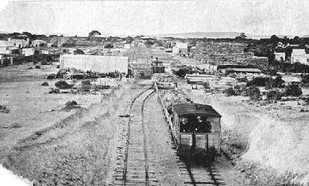
The Commission consisted of the Commissioner of Crown Lands (Hon. L. O'Loughlin, chairman), the Hons T. Pascoe, and A. von Doussa, and Messrs. P. Allen, H. Chesson, C. Goode, and W. Miller. Mr. E. B. Jones acted as guide to the party. The Commission set out from Cowell on Friday, April 23, and the record of the 14 days driving is as follows:- Friday, April 23, Cowell to Cleve, 30 miles; Saturday, April 24, to Arno Bay and back, 34; Sunday, April 25, to Sims' farm, 9; Monday, April 26, to Carrappee Hill, 15; Tuesday, April 27, to Cootra Rockhole, 28; Wednesday, April 28, to Weedina, 30; Thursday, April 29, to Pygery, 16; Friday, April 30, to Pinbong, 30; Saturday, May 1, to Kappakoola, 10; Sunday, May 2, at Kappakoola: Monday, May 3, to Terre station,. 30; Tuesday, May 4 to 200 gallon tank, 25; Wednesday, May 5, to Peechna, 17; Thursday, May 6, to Cummins, 35; total, 315 miles.
Quality of the Land
As indicated in Mr. Jones' report, the land varies from good red and chocolate-coloured sandy loam to light red and white sand, the red loamy soil predominating, while there is more red sand than white; but nearly all of it in the opinion of the farming members of the Commission capable of producing good crops of wheat with up-to-date methods of farming. Some of the land traversed is equal to the best mallee land on this side of Spencer's Gulf, carrying high mallee (in many, places over 30 ft m height, with odd trees up to 60 ft. ) In other places the mallee, though not so tall, is very uniform: ideal mallee for rolling down, and so dense that a splendid burn is assured those to whose lot it may fall to clear it. On the lighter sands the mallee is of a dwarf nature, from 3 to 6 ft in height, and intermixed with broom and other bushes; but here and there the monotony of the mallee is broken by an open grassy plain, while clumps and belts of pine give quite a park-like appearance to the richer spots of the land on which they thrive so well.
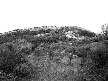
The Granite Hills.
A special feature of the country is the immense granite hills which rise for hundreds of feet out of (seemingly) almost endless plains of mallee. The first which came into view was Carrappee Hill; at the foot of which, in a fine patch of pines, we found a Government survey party, in charge of Mr. Evans, who kindly placed his tents at our disposal. Several members of the Commission, with Mr. Evans, ascended the mountain (for it is worthy of that designation), and although the weather was too misty for an extensive view, the glimpses here and there that we were able to secure amply repaid those who braved the elements, and wet bushes and the steep accent to get to the highest point. At the foot of Carrappee, on its northern side, is a magnificent patch of sheoaks, some two or three hundred acres in extent - probably the finest belt of sheoaks in the State.
About six miles in a westerly direction from Carrappee Hill seven sharp angular peaks of granite in conjoined and ascending succession cumulate in the highest point named Darke's Peak (so called after explorer Darke, who was fatally speared by the blacks in the vicinity.) These peaks, running nearly north and south, are almost precipitous on the western-side. On the eastern slopes of the hills, which are almost wholly covered with mallee scrub, a peculiar feature is noticeable in that several narrow strips of mallee several feet higher than the scrub on either side of its length traverse the side of the hills in almost parallel lines. The explanation apparently is that there are regular fissures in the rocks, where the deeper soil causes the stronger growth of the mallee. About 32 miles north of Darke's Peak lies Caralue Bluff, a bald granite hill forming a strong contrast to the angular peaks of the former, and also unlike it and Carrappee Hill in that it is almost destitute of vegetation.
Water Conservation.
The granite hills I have attempted to describe must be seen to be appreciated, and no doubt in years to come they will be visited by many tourists and sightseers, but their value at present is of a far more practical kind. The slightest shower of rain causes the water to course down their rocky sides, and, soakage wells are to be obtained at the bases of most of them, but with the construction of reservoirs large quantities of water now shed off these hills could be impounded, providing the watering places, which will be necessary before this country can he successfully occupied by the early settlers. Mr. James states (in the report already referred to) "Water would, I believe, have to be derived from catchment, as there is no evidence that I am aware of to show that supplies could be obtained by sinking."
Certainly the provision of water is quite as important as railway communication, and early steps should be taken thoroughly to test the country by boring. Failing supplies from below, tanks, dams, and reservoirs will need to be constructed prior to throwing this land open for settlement. A vigorous policy of water conservation on the part of the Government would undoubtedly meet with approval on every hand, not only in this at present unoccupied country, but also in some of the settled districts, such as Cowell and Arno Bay, where the cartage of water is a heavy handicap to many of the settlers.
Camp Life.
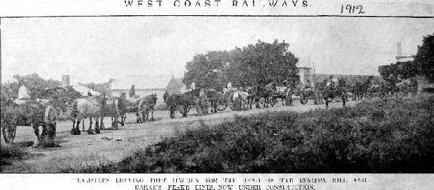
Commission visits of inspection are often nowadays referred to as Parliamentary picnics by those who remember the excursions of 20 or 30 years ago. To some of our members who brought back damaged clothes, and bags and boots, and whose overcoats were frequently to be seen steaming at the campfire while the owners of them changed their wet underclothing, the 14 days' drive was anything but a picnic. There were three or four days out of the 14 on which it did not rain, and on some days it rained all the time. On the first day out from Cleve a severe rain-storm drove the Commission to seek the ready hospitality of Mr. D. Sims, an up- to-date farmer, many miles from a port. Between Carrappee and the Cootra rockhole four of the members who had walked on after lunch were caught in a severe storm while in open country, and one umbrella proved insufficient to protect them. Towards the end of the trip the Commission had the wettest day of all. Breakfast was taken standing up in a sleety rain. There was not a dry spot to sit on, and camp was struck and a start made for Koolidie station with rain steadily falling, and with every indication of a very wet day. The journey for the most part was through mallee, and for part of the distance there was no track to follow. Every mallee branch held enough water for a shower bath, and it was impossible to avoid many of them. Oilskins, coats, and rugs were never of greater service, and yet several members were wet to the skin when they suddenly emerged from the mallee and pines on to the Peechna homestead of four unoccupied rooms. Mr. D. C. Dearrman, with Mr. J. Telfer, jun., had come out 11 mliles from the Oakdale station in anticipation of meeting us, and we were soon comfortably housed before a roaring fire. In spite of the unfavourable weather and the rough rides over the limestone country around Polda and Terre, not one member of the Commission would refuse to make the journey again were it necessary, because the camp life was thoroughly enjoyable, and wherever there was any population the Commission had a cordial and hospitable welcome. By the time the head of the railway-line was reached almost every member of the party was an expert at rig ging tents. At Terre we met a number of settlers from Talia, Polda, Bramfield, Elliston, and other places on the West Coast, who had
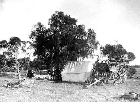
driven many miles to give evidence, and we heard afterwards that we created a favourable impression by the manner in which the camp was formed for the night. Our four-in-hand teams drew up in line, leaving room between each two traps for a tent. Tent-poles were up, tent pegs in, stretchers put together, and rugs spread in a trice, and an old settler remarked that he had never seen such smart work in his life. Some of the members had taken such pleasure in making themselves comfortable for the night, and in striking camp and loading the traps in the morning, that it was with some regret that they found on arrival at Cummins that a small railway goods-shed was available, and that the last night had been spent under canvas. The feelings of regret were softened by a final pelting shower of rain.
At Cummins.
Banquets were tendered to the Commission at Cowell, Cleve, and Cummins, not with any desire to influence the members of the Commission in any way, but as demonstrations of welcome. A concert was also held in honour of the Commission at Cummins, and like the luncheon, it was attended by a fine lot of young farmers, who, although faced with various difficulties, were confident of ultimate success, and who had no misgivings as to the future of the Peninsula when the necessary railway facilities were provided. Mr. Siviour, in welcoming the Commission at the luncheon, congratulated the Government on their choice of members of the Commission, and expressed the hope that regard would be had to the necessity not only of trunk lines but of feeders. He declared amidst cheers that he hoped to live to ride to Streaky Bay by railway. He also alluded to the necessity of giving special grants to district councils for grubbing roads in new hundreds. The Commissioner of Crown Lands, in responding, predicted there was a great future before Eyre Peninsula, and he explained that they had only become aware of the fact since the effect of superphosphates on mallee land had been demonstrated. He went on to say that it was the desire of the Government to open up any Crown lands that were suitable, or any large estates that were available. Some people complained that the Government were settling people on the land too cheaply, but pioneers who came to Eyre Peninsula without railway facilities and water supply and grass for stock deserved all that the Government could do for them. The amount of the rent did not matter so long as there was prosperous settlement and settlers should not be handicapped in the initial stages of their work. He was quite certain there was an area of a million acres of land to open up on Eyre Peninsula, (Hon. A. von Doussa - "More.") Half of that was tip-top land, equal to any mallee land in South Australia, and the other half could be made much better by an up-to-date system of farming.
The Evidence.
Evidence was taken by the Commission at Cowell, Arno Bay, Cleve, Weedina, Kappakoola, Terre, Peechna, Cummins, and Port Lincoln. Practically every witness agreed as to the vast extent of arable land suitable for settlement, and what rainfall records were available went to show that Mr Jones' estimate of a rainfall of 14 or 15 in. was a safe one. Perhaps the most interesting witness of all was Mr. Alfred King, of Port Lincoln, who arrived on Eyre Peninsula in 1850, and who has made many excursions into the interior. Although he has not been over the country for about 50 years, he described it most accurately. He had many adventures with the blacks, and could relate the circumstances of more than one murder and theft of sheep committed by them. He related to the Commission that the grave of Darke, the explorer, who was murdered by the blacks, was pointed out to him by a native. It was, he said, in a clump of pines at the foot of the hill now called Darke's Peak, and he expressed the opinion that he would be able to find the spot again. It is possible that something may be done to mark the resting-place of one who lost his life in the pursuit of exploration. Probably Mr. King is the only person in South Australia who can give any information on the subject.
While the witnesses were unanimous as to the splendid character of the land in the vicinity of Weedina, several of them stated that equally good country existed in a westerly and north-westerly direction, and that there was a good shipping place with deep water in Decree Bay. It is probable that this land will be inspected. No date for this "picnic" can yet be given, because the Commission has now to face the problem of railway routes, and the claims of Port Lincoln, Arno Bay, Cowell, Tumby Bay, as well as the ports on the West Coast, and the question of light feeder lines to the hundreds of Kiana, Mitchell, and Ulipa, and Brooker, Moody, and Butler, have to be considered.